File:Clay County MN 1859 Survey At Mouth Of Sheyenne River.jpg
From The Infomercantile
Jump to navigationJump to search
Size of this preview: 352 × 598 pixels. Other resolutions: 141 × 240 pixels | 1,000 × 1,700 pixels.
Original file (1,000 × 1,700 pixels, file size: 521 KB, MIME type: image/jpeg)
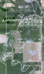
The 1959 Clay County, Minnesota survey map (found here), overlayed on a 21st century aerial map of the area around the Sheyenne River outlet.
File history
Click on a date/time to view the file as it appeared at that time.
| Date/Time | Thumbnail | Dimensions | User | Comment | |
|---|---|---|---|---|---|
| current | 23:15, 12 September 2009 | | 1,000 × 1,700 (521 KB) | AzraelBrown (talk | contribs) | The 1959 Clay County, Minnesota survey map ([http://www.lmic.state.mn.us/surveydata/clay/ppi200_l0/t141r49w5fi01.pdf found here]), overlayed on a 21st century aerial map of the area around the Sheyenne River outlet. |
You cannot overwrite this file.
File usage
The following page uses this file: