File:Forests, Deserts, and Prairies of the World, 1900s.jpg

Original file (3,061 × 1,856 pixels, file size: 1,012 KB, MIME type: image/jpeg)
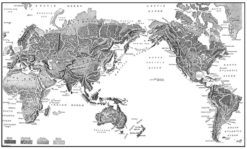
This is a single map combined from several smaller maps that appeared on pages 3074-3075 of The Children's Encyclopedia, published in the early 1900s. It depicts, without the impedance of national borders, the various locations of forests, deserts, and prairies around the world. The captions at the bottom of each page reads:
We all know that the moon has no water on its surface, in other words, that it has dried up. But not so many people are aware that our own earth is drying up, and that the deserts are spreading. In this map of the Old World we can see at a glance where the forests, the woodlands, and the grassy plains are; and we see also the great desert belt stretching right across Africa and Asia. Inland waters like the Caspian Sea are becoming shallower as the years go by, and in the desert of Gobi, in Central Asia, a great lake called Lob-nor has dried up within the last century or so. The great Swedish explorer Dr. Sven Hedin found in this desert remains of the great cities and trade routes, proving that a few hundred years ago it was a flourishing, fertile country.
In the New World the same process of drying up is going on, and in Arizona there is a desert where once was a flourishing forest. We can see in this map the great forests and grass plains of America, which are fast disappearing as the population increases. The wholesale removal of the forests is a disastrous thing for a country. The reckless destruction of protecting pine forests in the French Alps last century, for instance, led to the steep mountain-sides being washed bare of soil, and, as a result, in thirty years the population decreased by over 25,000. The great treeless plains of North America are called prairies, meaning "meadows." In South America they are called pampas, meaning "plains," and in Europe we call them steppes, which is Russian for "heaths."
File history
Click on a date/time to view the file as it appeared at that time.
| Date/Time | Thumbnail | Dimensions | User | Comment | |
|---|---|---|---|---|---|
| current | 00:20, 13 April 2009 | | 3,061 × 1,856 (1,012 KB) | AzraelBrown (talk | contribs) | This is a single map combined from several smaller maps that appeared on pages 3074-3075 of The Children's Encyclopedia, published in the early 1900s. It depicts, without the impedance of national borders, the various locations of forests, deserts, |
You cannot overwrite this file.
File usage
There are no pages that use this file.