File:Howard Binford's Guide Map, 1985.jpg

Original file (1,500 × 1,015 pixels, file size: 566 KB, MIME type: image/jpeg)
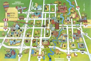
This map was the center spread in many of the 1980s-era Howard Binford's Guides. Stylishly 1970s, it artfully shows Fargo and Moorhead's extent at that time. I have vivid memories from my childhood of being given a copy of the Guide to occupy myself while waiting for food in restaurants and examining this map in great detail.
Background
The map premiered in the April issue of Howard Binford's Guide. Binford explains the map's origin:
[D]esigned by David Hetland (our cover profile subject in the October 1984 issue) and executed by Gary Baune of the Hetland Ltd. staff -- for exclusive use in The Guide and by the Fargo-Moorhead Convention and Visitors Bureau.
The notes also indicate that the map was being "considered" for printing at poster-size; interested parties were to contact Binford or the FM Convention & Visitors Bureau.
Key
F-M area landmarks are noted by numbers on the map following the key listed below:
- RRV Fairgrounds
- Bonanzaville USA
- Factory Outlet Mall
- Village West Shopping Center
- Oak Park Plaza
- West Acres Shopping Center
- Homestead Mall
- LaBelle's Plaza
- Market Square
- K-Mart Plaza
- Southside Shopping Center
- Dakota Medical Center
- Lindenwood Park
- Island Park
- St. John's Hospital
- The Depot / Visitor's Center
- Downtown Fargo
- St. Luke's Hospital / Fargo Clinic
- Civic Memorial Auditorium
- Michelson Field
- North Dakota State University
- Hector International Airport
- Northport Shopping Center
- Veteran's Administration Center
- Trollwood Park
- St. Ansgar Hospital
- Moorhead Center Mall
- Plains Art Museum
- Moorhead State University
- Concordia College
- Gooseberry Mound Park
- Brookdale Shopping Center
- Holiday Mall Shopping Center
- Moorhead Area Vocational and Techinical Institute
- Red River of the North
File history
Click on a date/time to view the file as it appeared at that time.
| Date/Time | Thumbnail | Dimensions | User | Comment | |
|---|---|---|---|---|---|
| current | 21:41, 23 April 2007 | | 1,500 × 1,015 (566 KB) | AzraelBrown (talk | contribs) | This map was the center spread in many of the 1980s-era Howard Binford's Guides. Stylishly 1970s, it artfully shows Fargo and Moorhead's extent at that time. ==Key== '''F-M area landmarks are noted by numbers on the map following the ley listed |
You cannot overwrite this file.
File usage
There are no pages that use this file.