File:Howard Binford's Guide Map, 1985.jpg
From The Infomercantile
Revision as of 21:41, 23 April 2007 by AzraelBrown (talk | contribs) (This map was the center spread in many of the 1980s-era Howard Binford's Guides. Stylishly 1970s, it artfully shows Fargo and Moorhead's extent at that time. ==Key== '''F-M area landmarks are noted by numbers on the map following the ley listed )

Size of this preview: 800 × 541 pixels. Other resolutions: 320 × 217 pixels | 1,500 × 1,015 pixels.
Original file (1,500 × 1,015 pixels, file size: 566 KB, MIME type: image/jpeg)
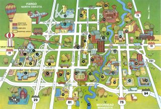
This map was the center spread in many of the 1980s-era Howard Binford's Guides. Stylishly 1970s, it artfully shows Fargo and Moorhead's extent at that time.
Key
F-M area landmarks are noted by numbers on the map following the ley listed below:
- RRV Fairgrounds
- Bonanzaville USA
- Facroty Outlet Mall
- Village West Shopping Center
- Oak Park Plaza
- West Acres Shopping Center
- Homestead Mall
- LaBelle's Plaza
- Market Square
- K-Mart Plaza
- Southside Shopping Center
- Dakota Medical Center
- Lindenwood Park
- Island Park
- St. John's Hospital
- The Depot / Visitor's Center
- Downtown Fargo
- St. Luke's Hospital / Fargo Clinic
- Civic Memorial Auditorium
- Michelson Field
- North Dakota State University
- Hector International Airport
- Northport Shopping Center
- Veteran's Administration Center
- Trollwood Park
- St. Ansgar Hospital
- Moorhead Center Mall
- Plains Art Museum
- Moorhead State University
- Concordia College
- Gooseberry Mound Park
- Brookdale Shopping Center
- Holiday Mall Shopping Center
- Moorhead Area Vocational and Techinical Institute
- Red River of the North
File history
Click on a date/time to view the file as it appeared at that time.
| Date/Time | Thumbnail | Dimensions | User | Comment | |
|---|---|---|---|---|---|
| current | 21:41, 23 April 2007 | | 1,500 × 1,015 (566 KB) | AzraelBrown (talk | contribs) | This map was the center spread in many of the 1980s-era Howard Binford's Guides. Stylishly 1970s, it artfully shows Fargo and Moorhead's extent at that time. ==Key== '''F-M area landmarks are noted by numbers on the map following the ley listed |
You cannot overwrite this file.
File usage
There are no pages that use this file.