Difference between revisions of "Trysil, North Dakota"
AzraelBrown (talk | contribs) |
AzraelBrown (talk | contribs) |
||
| Line 1: | Line 1: | ||
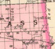
| − | [[Image:Trysil,_North_Dakota_1878.jpg|thumb|right|Trysil, ND]]September 2nd, 1873, Norwegian homesteader Ole Strandwold | + | [[Image:Trysil,_North_Dakota_1878.jpg|thumb|right|Trysil, ND]]September 2nd, 1873, Norwegian homesteader Ole Strandwold staked his claim on the SW¼ of section 24, township 143, range 49 in Clay County, North Dakota, around 8 miles north of [[Dakota City, North Dakota|Dakota City]], around 6 miles east of the current location of [[Gardner, North Dakota]] and established the town of Trysil; shortly thereafter a Norwegian Lutheran church was built and named Trysil Lutheran Church. The Trysil name did not last: the church changed its name to Nora Lutheran Church in 1885<ref>http://www.geocities.com/noralutheran/history.html History of Nora Lutheran Church, retrieved 8/1/09.</ref>, and Strandwold's post office was eliminated in 1899<ref>[[Origins of North Dakota Place Names, Mary Ann Barnes Williams]]</ref>. |
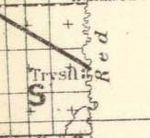
| − | [[Image:Proposed Northern Pacific Line, Passign Near Trysil, ND 1879.jpg|thumb|left|150px|Proposed Trysil crossing]] | + | [[Image:Proposed Northern Pacific Line, Passign Near Trysil, ND 1879.jpg|thumb|left|150px|Proposed Trysil crossing]]The location of Trysil would place it across the river from the Gerogetown Hudson Bay Trading Post, rather than Georgetown itself as some maps would indicate. An 1879 map shows a proposed Northern Pacific rail line crossing of the Red River would have passed very near Trysil, connecting to Fort Totten, ND (see left). |
Revision as of 20:52, 4 September 2009
September 2nd, 1873, Norwegian homesteader Ole Strandwold staked his claim on the SW¼ of section 24, township 143, range 49 in Clay County, North Dakota, around 8 miles north of Dakota City, around 6 miles east of the current location of Gardner, North Dakota and established the town of Trysil; shortly thereafter a Norwegian Lutheran church was built and named Trysil Lutheran Church. The Trysil name did not last: the church changed its name to Nora Lutheran Church in 1885[1], and Strandwold's post office was eliminated in 1899[2].
The location of Trysil would place it across the river from the Gerogetown Hudson Bay Trading Post, rather than Georgetown itself as some maps would indicate. An 1879 map shows a proposed Northern Pacific rail line crossing of the Red River would have passed very near Trysil, connecting to Fort Totten, ND (see left).
References
- ↑ http://www.geocities.com/noralutheran/history.html History of Nora Lutheran Church, retrieved 8/1/09.
- ↑ Origins of North Dakota Place Names, Mary Ann Barnes Williams

