 |

| |
|
|  |
Antarctica, 1890s.
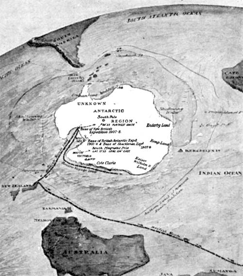
Click for full image It is usually left off of world maps, but in this one Antarctica is the guest of honor. Most flat map projections, even if they do include Antarctica portray it as a wide band of white, with little visualization of how it actually appears. Above is a map viewing the spherical Earth from a southerly position, providing the least distortion to Antarctica, but giving a very different view of where South America, South Africa, New Zealand, and Australia lie in relation. The map's purpose is to show various expeditions to locate the South Pole; the map was reduced such that the labels are almost unreadable even in the original. From the multivolume The Book of History, 1890s. Labels: 1890s, antarctica, exploration, maps
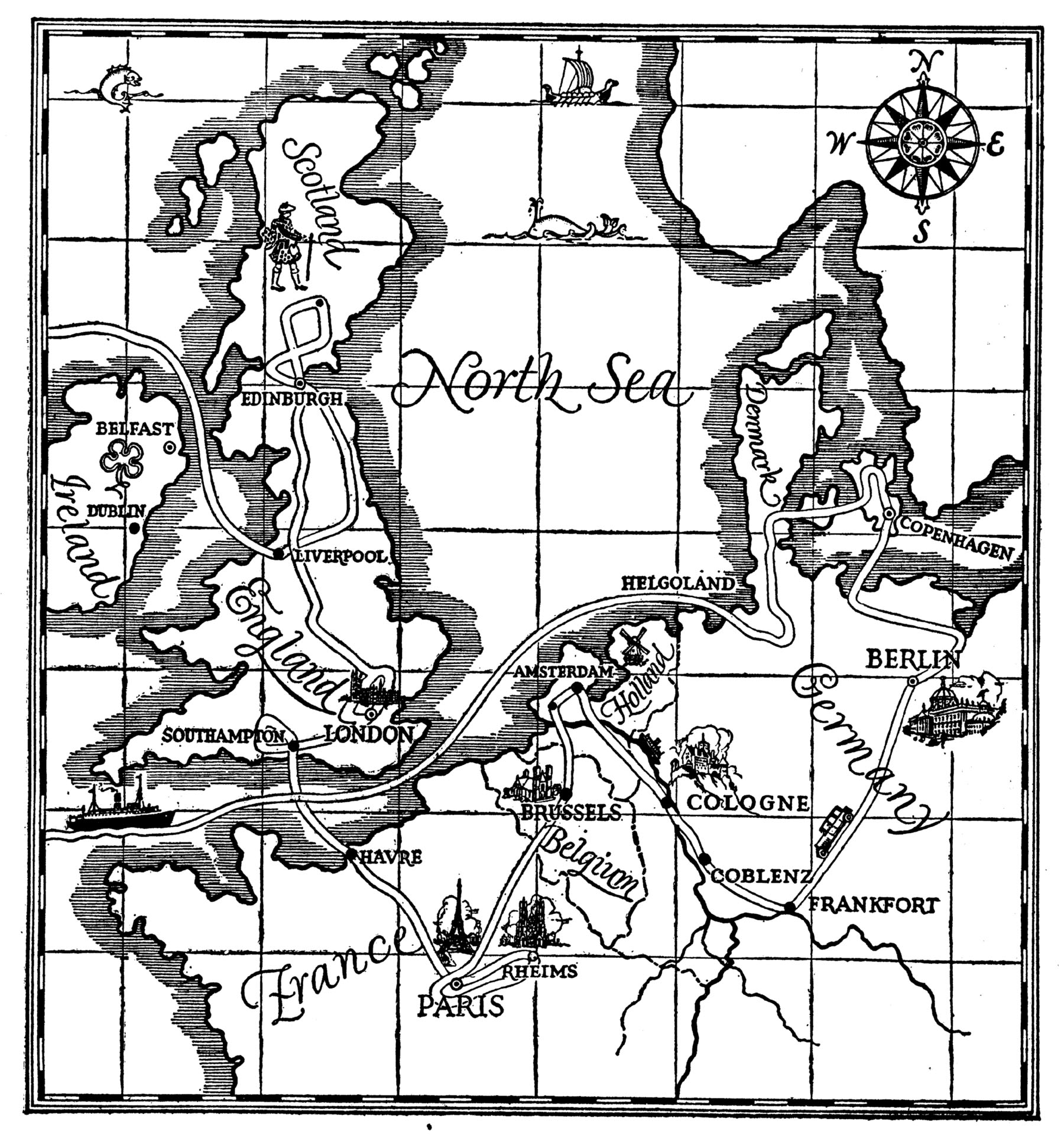
Trip Around The North Sea, 1927.
Forests, Deserts, and Prairies, 1910s.
Click for full image From The Children's Encyclopedia, published in the 1910s, and designed by "G.F. Morrell". This illustrated map, ignoring political boundaries and man-made roads or railways, is pieced together from several smaller maps, depicting the various environments of the world. The caption of the maps engages in some scare-mongering, comparing the expanding deserts as proof our planet is moving towards being as arid as the moon, but it also describes deforestation as "a disastrous thing for a country," recognizing that removal of trees and grasses can result in loss of topsoil and a collapse of the food-creating industries. Labels: 1910s, environmentalism, illustration, maps, the children's encyclopedia
Dakota City, North Dakota, 1890s.
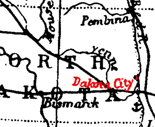
Click for full imageGreetings from scenic Dakota City, North Dakota! It took a little research to figure out what the cartographer was going off of, but the issue may be the result of lazy mapmaking. The full-sized map comes from the Harmsworth Self-Educator, a British encyclopedia from the 1910s. On closer examination, it's odd to see a river called the "Yenne" running curling around the eastern half of the state — that is actually the "She yenne River", which had at some point lost the first part of its name. The mapmaker who produced the map during the 1890s was copying off a map about 40 years older. "Dakota City" was a small settlement, just north of the Sheyenne/Red River confluence about ten miles north of Fargo, north of Harwood's current townsite, established in the 1850s. According to Origins of North Dakota Place Names by Mary Ann Barnes Williams, "In 1895, one log cabin stood at the crossing of the Red River, just opposite LaFayette, Minn., on the Dakota side...known as Dakota City." That one lone log cabin was occupied in the 1860s by "Monsieur Marchaud, a French Canadian, his Chippewa wife and twelve children," according to Seat of the Empire by Charles Coffin. Dakota City, its neighbor Lafayette, and numerous other small townsites never succeeded in reaching actual town status, disappearing well before this map was published. Labels: 1890s, dakota city, maps, north dakota history
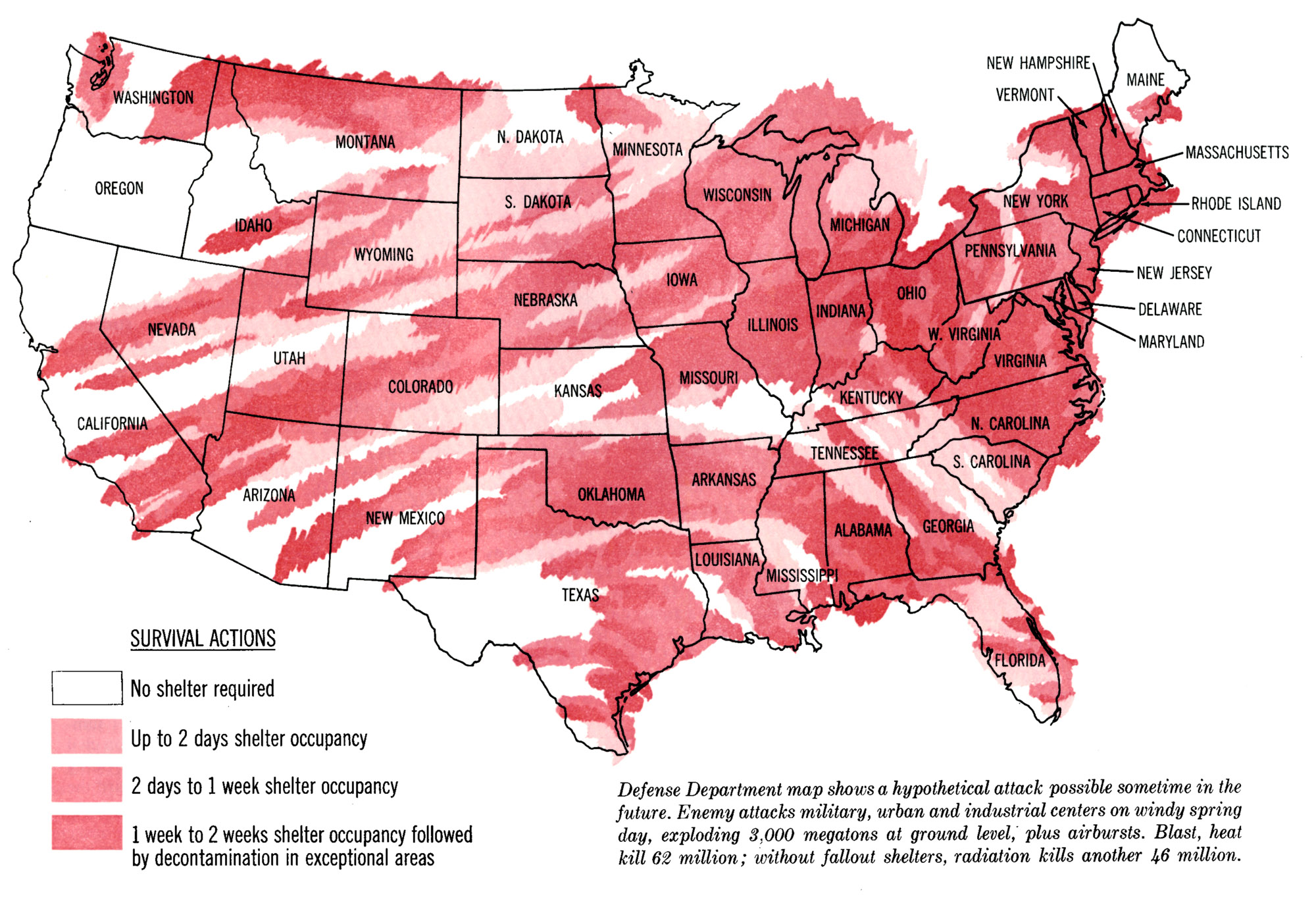
Cold War Wind Patterns, 1963.
Click for full imageWhat does this map show? It relies on the wind patterns of an average spring day, in that particular decade. That decade was the 1960s, and about the biggest worry to be carried on those spring winds: fallout. This map projects fallout, if an "enemy" were to drop 3,000 megatons on various military, industrial, and civilian targets at the same time, both ground detonations and air bursts. From the Saturday Evening Post, 23 March 1963. Labels: 1960s, 1963, cold war, fallout shelter, maps, saturday evening post
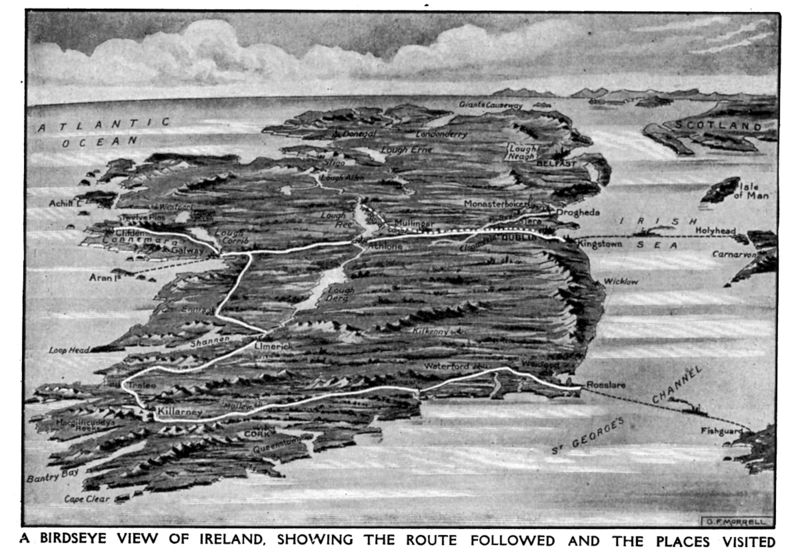
Orthographic Ireland, 1910s.
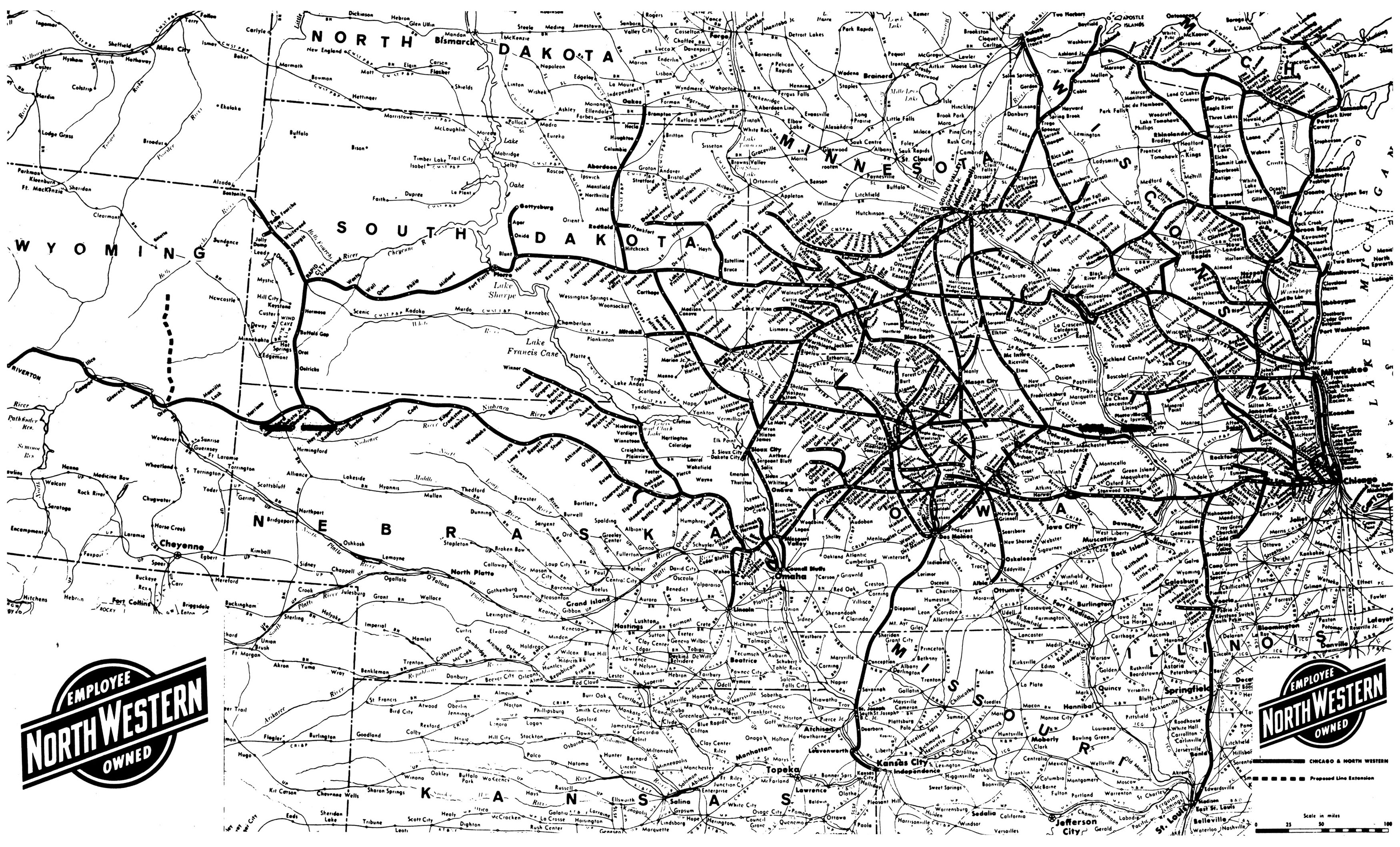
Chicago and Northwestern Railroad, 1977.
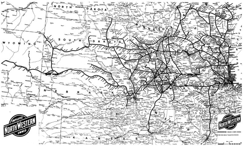 Map of the towns serviced and tracks used by the Chicago and Northwestern Railroad, effective as of 1 August 1977. Scanned from a small centerfold in the railroad's timetable booklet. Labels: 1970s, 1977, maps, railroad
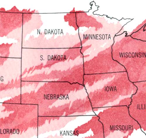
Climate Map of North America, N.D.-Centric, 1929.
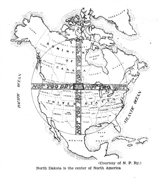 Saying " North Dakota is the center of North America" is a factual truth; just outside Rugby N.D. is a monument to that fact. What's more remarkable is the interpretive turn: the map paints North Dakota as the baby bear's porridge of our continent. West is Too Dry, north is Too Cold, east is Too Wet, and south is Too Hot. North Dakota meets in the middle, and is thus the perfect place to live, right? I'm a fan of the state, you know, but we're actually in a position that gets all of the above: deadly droughts, destructive floods, sub-zero winters and 100°+ summers. It seems the cartographer who drew the map was mistaking us for Hawaii. I know, it's an easy mistake to make, but it's an over-simplification of what North Dakota's climate is like. Labels: 1929, maps, north dakota history
Cape Cod Illustrated
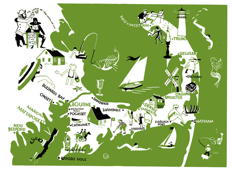 This map This map, short on words but large on illustrations, diagrams just a small portion of Massachusetts known as Cape Cod. It was printed as part of a booklet by the New York, New Haven, and Hartford Railroad Co (which, in turn, was part of a 7-booklet set covering the entirety of the railroad's reach). The booklets were designed for tourists and encouraged them to contact the railroads internal 'travel bureau', as though East Coast residents had no idea the Cape was known for its beaches and fishing -- although its target was probably not locals, but folks like me from the flyover states who'd be intrigued by the treasure chest marked " Kidd". I had no idea his lost treasure was marked so clearly on local maps! Labels: 1950s, cape cod, maps, railroad
Fauna of the USSR
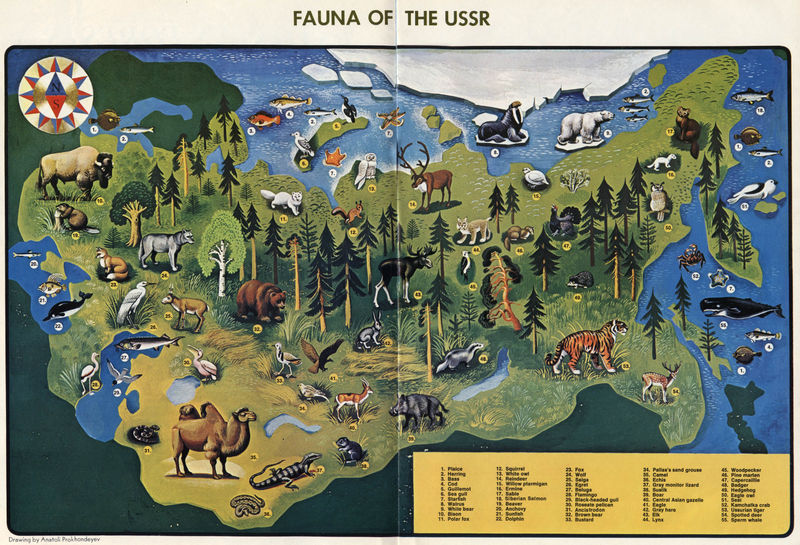 To avoid appearing American-centric, here's a map of the USSR's wildlife from 1972. A decade or two after the USA wildlife map I posted a couple weeks ago, this USSR map comes from the pages of Soviet Life Magazine ( see also) . It shouldn't be surprising, but the similarity to our American wildlife is readily visible. Both countries cover similar climates, span comparably mountainous, arid, wet, warm, and cold areas, and were (geologically speaking) connected not too long ago. It shouldn't be a shock to find deer, moose, bears, badgers, and so forth. There's a few asia-centric critters here, such as monitor lizards, camels, and tigers, but compared to our mountain lions, alligators, and turkeys we locals tend to forget that rather exotic creatures live in our backyards. The USSR map seems to have far fewer critters than the US, but that accounts for American excessiveness: the US map has a lot of repetition; look around the edge of the map for a more accurate count, and we'd be about the same if it weren't for all the different bird variants on the US map. Labels: 1970s, 1972, maps, ussr, wildlife
San Francisco, via Gray Line
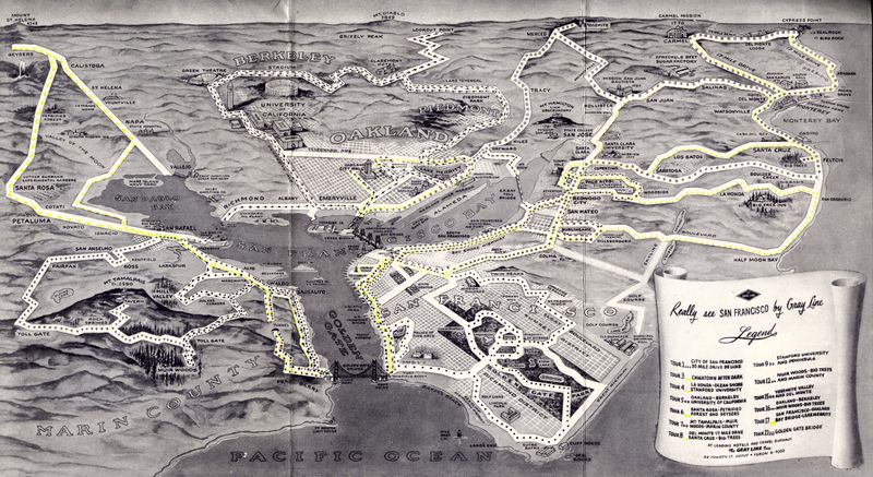 San Francisco still has Gray Line offering bus tours of their beautiful city, all these years later. The map above is from 1953, from a pamphlet called "Really See San Francisco." I'm just including the map here, but the rest may follow someday. Nearly 60 years ago, here's what the attractions via a bus tour were: - Deluxe 30-mile drive around San Francisco
- Chinatown After Dark
- La-Honda, Ocean shore, and Stanford University
- Oakland, Berkeley, and U of Calif.
- Santa Rosa, Petrified forest and geysers
- Mt Tamalpais, Muir Woods, and Marin County
- Del Monte, Santa Cruz
- Stanford University and peninsula
- Muir Woods, big trees, and Marin County
- Yosemite Valley and Del Monte
- Oakland, Berkeley, Muir Woods, big trees
- San Francisco, Oakland, Bay Bridge, Lake Merritt
- Golden Gate Bridge
All you had to do was dial Yukon 6-4000, and you could hit the road in style! I'm impressed that Del Monte was such a large part of the various tours -- post WWII, it had mostly been taken over by the Navy School, although all the land around the hotel was full of gardens, woods, and golf courses, still accessible to tourists at the time. "Chinatown after dark" is an interesting name: while the tour, given the clientèle of city bus tourists, was probably quiet and unoffensive for the time, I wonder if it was tied-in to the movie of the same name from 1931. As for the map itself: I'm a fan of purposeful maps, ones that don't spare the information about what it feels relevant, but ignores the irrelevant whenever possible. This isometric view includes landmarks and gives a nice sensation of distance, which then also lets riders know how much time will be spent looking out the window at non-landmarks. Labels: 1950s, 1953, california history, gray line, maps, san francisco
The Byelorussian Soviet Republic: 1971
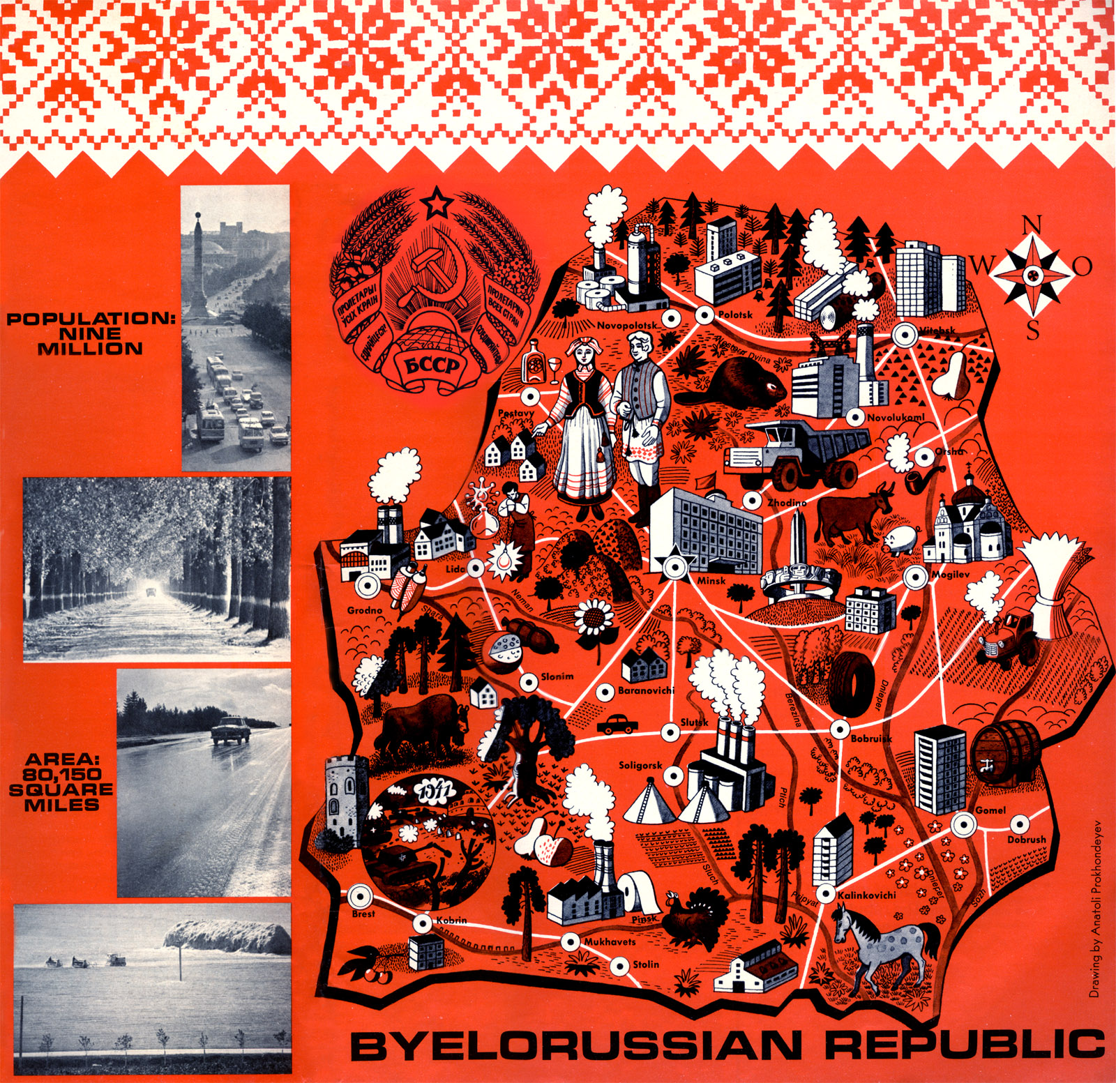 This map appeared in the front cover of the December 1971 issue of Soviet Life magazine. Soviet Life, as you might have guessed, has grown along with its namesake, becoming Russian Life today. Back in the 1970s, the magazine presented the Soviet Union in a less-than-propagandic way, avoiding too much political content and focusing on common life in the USSR. It made it into the hands of Americans, under the agreement that the Soviet regime would distribute the magazine America to citizens of Russia. In this issue, we learn of Belorussia's contributions to the world, its participation in WWII and the United Nations, and its advances in arts and sciences. Most all of the article content can be found condensed into this illustrated map, showing off everything from classic styles of dress to cheese to construction equipment. The big logo in the middle is the Soviet-era symbol of Belarus, slightly different from an earlier style (which in turn was based on a general Soviet symbol): today's symbol is strikingly similar, but exchanging the hammer and sickle for their own nation's outline. While retaining some Soviet symbolism, the country changed its name from the Soviet-sounding "Belorussia" to "Belarus" with their independence. Labels: 1970s, 1971, belarus, maps, soviet, ussr
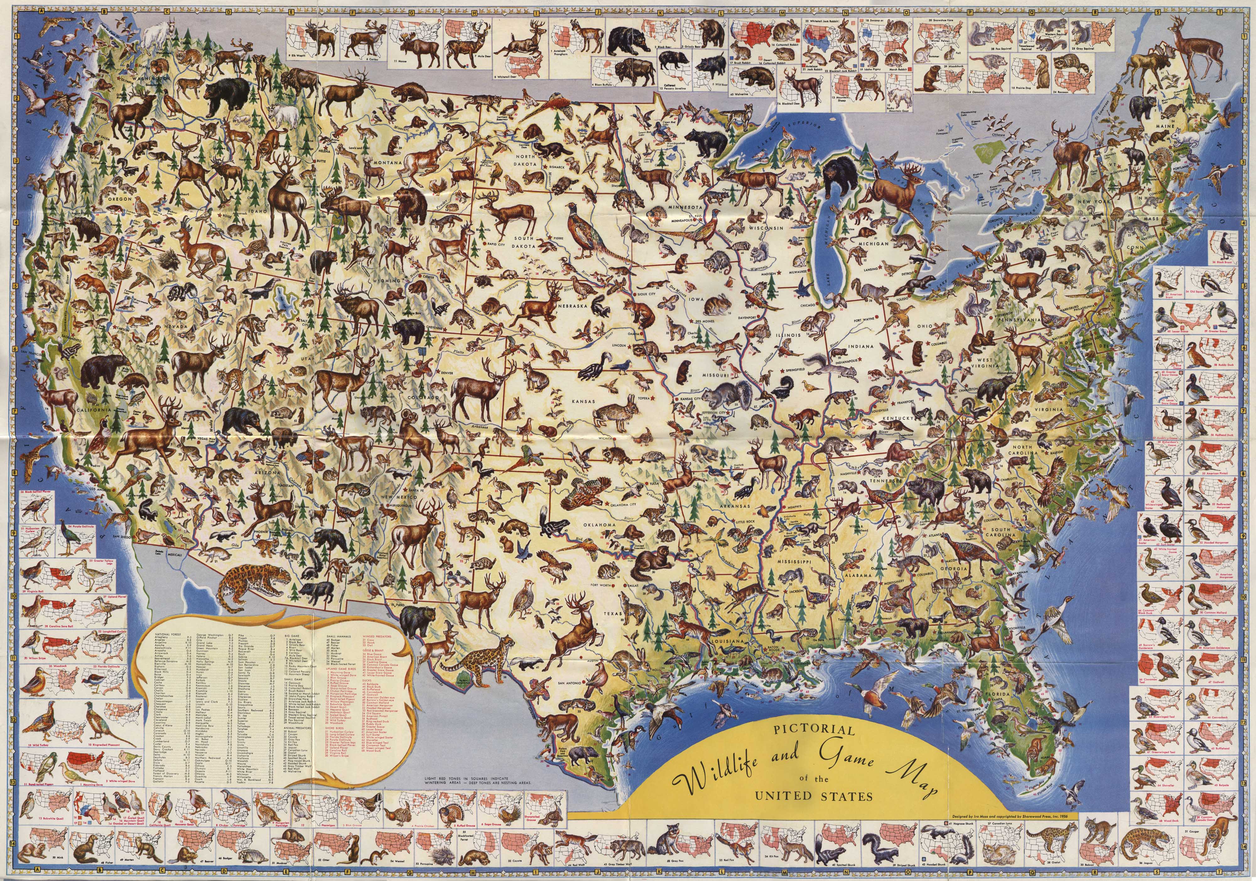
Where Do The Animals Live?
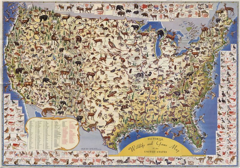 This is a " Pictorial Wildlife and Game Map" from 1956. Unlike a population map or 'Game of the States", this documents those critters we hate to have around, but really don't want to disappear. In terms of information use, the map is very cluttered, but it does an pretty job of covering migration ranges and general locations. The central map shows the general locations of a variety of animals' habitats, and around the edge we see species-specific ranges outlined in red. The hundreds of tiny animal drawings are excellent -- I did my best to make it as large as possible to get more detail for you, but hitting my webserver's limit of memory kept is smaller than I'd have liked. Still, the big version should give you a pretty good idea of who's living where. [more maps] Labels: 1950s, 1956, data visualization, habitat, information design, maps, wildlife
Look At Old Chicago
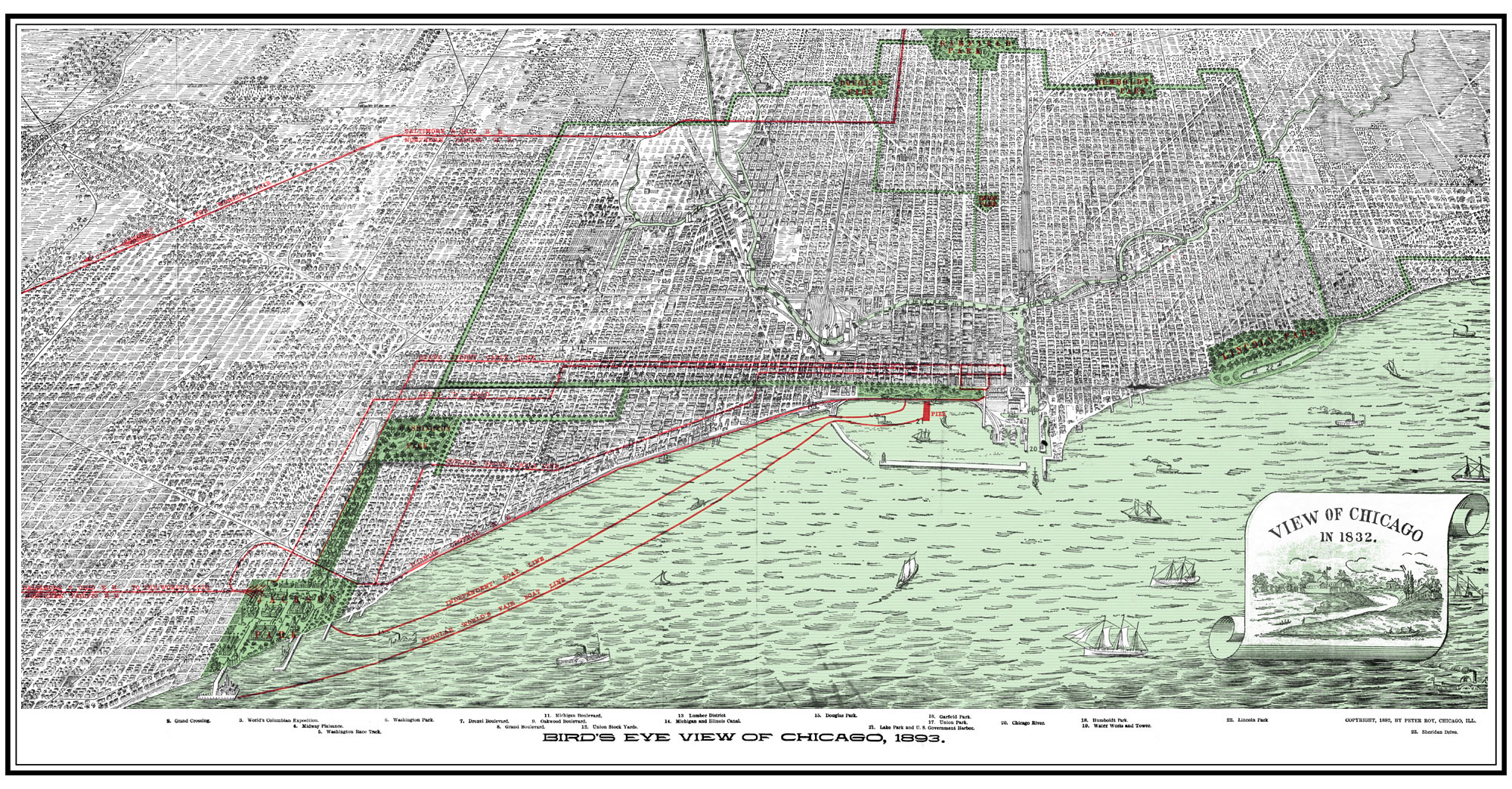 Think you know Chicago? This map will probably interest you. Live in old Chicago? You can probably see your house from here. Distributed for the 1893 World's Exhibition, on this side it shows an entire map of Chicago -- which, in pre-automobile-times, was probably as difficult to cross as it is to travel across entire states today. Without Google Maps, AAA, or even a casual knowledge of the city beyond a half-mile, people needed to know how to get from their home to the Expo: a city-wide map was necessary. The back has pictures of various features in the Expo -- I may get around to scanning it eventually. Labels: 1890s, 1893, chicago, maps, world's exhibition
| |
|
|


